It was said that The sun never set on the British Empire. Of course, the oft-quoted rebuttal to that statement is "Even god didn’t trust the British in the dark".
In its heyday, the British Empire spanned about a quarter of the land-mass of Earth, and about a quarter of the world population were subjects of the monarchs of the House of Windsor. Now even though that’s a pretty impressive statistic, the statement "sun never sets" is quite grandiose. It implies that the British Empire spanned the Earth so completely, that the time-zone difference between the biggest gaps were less than a few hours.
Is that true ?
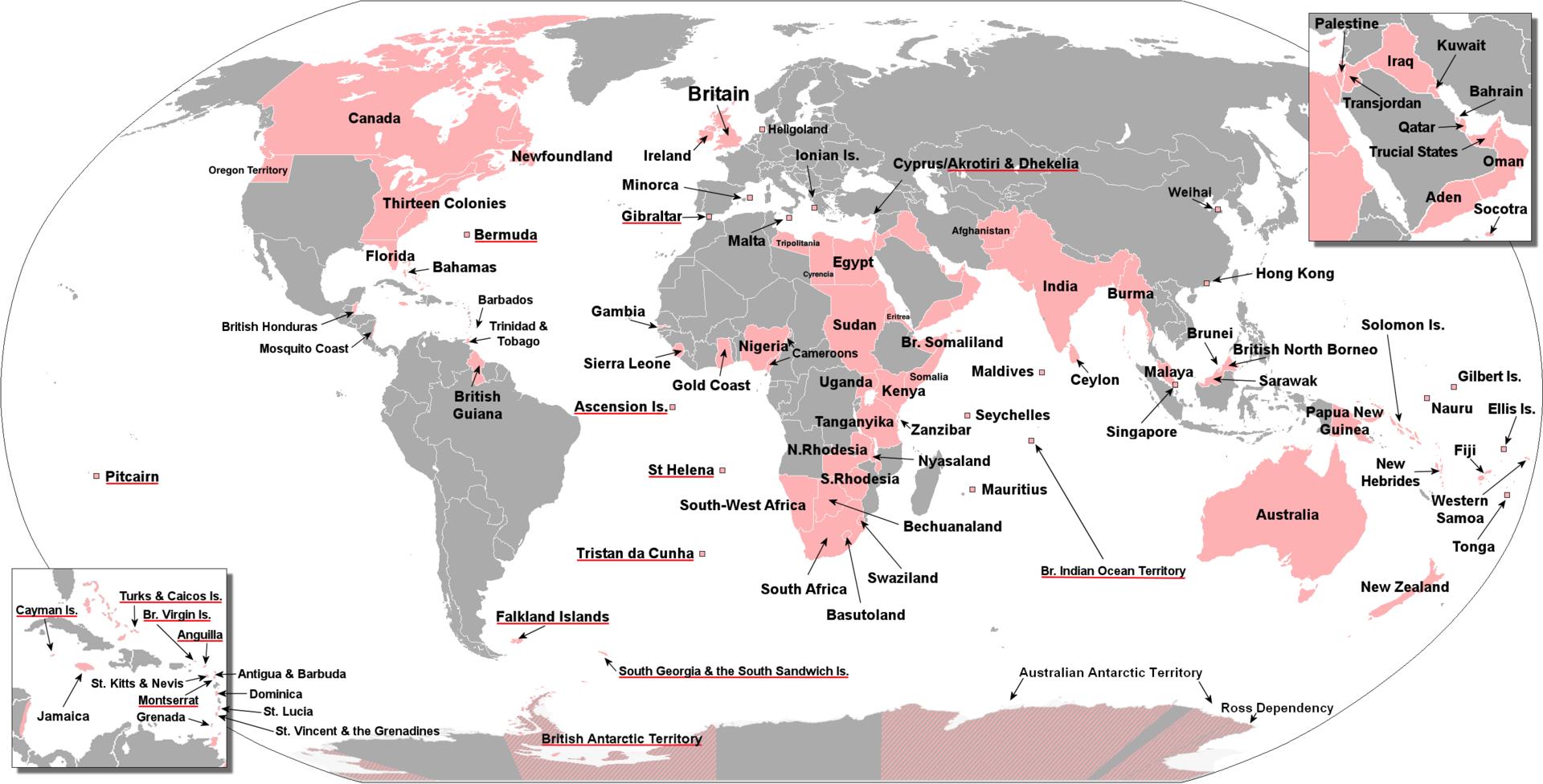
First, let’s have a look at the map, shamelessly filched from Wikipedia. The legend, though not visible clearly, basically indicates colonies, dominions, colonies of dominions, puppet governments etc.
Starting from the east at the International Date line, let’s traverse the map to the west.
- Polynesia (Samoa, Fiji, Tonga, Vanuatu, Solomon Islands).
- Asia Pacific (New Zealand, Papua New Guinea, Australia, Hong Kong, Shanghai)
- South-east Asia (Malaysia, Singapore, Thailand)
- South Asia (Myanmar, India, Bangladesh, Tibet, Bhutan, Nepal, Pakistan, Afghanistan)
- Middle East (Yemen, Oman, UAE, Iraq, Jordan, Lebanon, Israel, Palestine)
- Africa (Egypt, Sudan, Eritrea, Djibouti, Parts of Somalia, Kenya, Uganda, Tanzania, Zambia, Malawi, Zimbabwe, South Africa, Namibia, Botswana, Nigeria, Parts of Cameroon, Togo, Ghana, Sierra Leone)
- Europe (England, Scotland, Ireland, Wales, Cyprus and a few Mediterranean Islands)
- South America (Guyana)
- Central America (Belize, Many of the Carribean Islands, collectively known as the West Indies)
- North America (Canada, Eastern and Mid-west USA, and Washington)
Now, the world is divided into 360 degrees of longitude, and each degree is 4 minutes long. So to ratify the claim that the "Sun never set", let us calculate, approximately, the greatest longitudinal distance between two parts of the British Empire.
I think we can safely skip the land masses, since the British Empire was nearly contiguous there. The biggest gap between two parts of the empire is never more than an hour in time zone, so let’s just tackle the two biggest gaps in land mass, the Atlantic Ocean and the Pacific Ocean.
The Atlantic is easy. Canada stretches from approximately 50W to 140W, which means that that Canada is only 50 degrees away from Greenwich. Closer to the Equator, Sierra Leone is at 13 degrees west, and Guyana at 59 degrees. That’s only 46 degrees, so the Atlantic is pretty much covered.
The western-most part of the British empire is again Canada, clocking in a 140 degrees west. The eastern-most part would be some of the polynesian islands, but let’s just account for New Zealand, which is 174 degrees east of the Greewich meridian. Distance in degrees from Canada: again, 46.
Conclusion: There were never two parts of the British empire which were more than THREE hours apart. The sun, indeed, never set on the British Empire.
It reminds me of a song by the band "The Kinks", called Victoria:
Let her sun never set
Victoria, victoria, victoria, toria
Land of hope and gloria
Land of my victoria
Land of hope and gloria
Land of my victoria
Victoria, toria